Every year, roughly 650,000 Christian pilgrims visit Israel. Most follow a two-week itinerary that hasn’t changed much since the 19th century. They stand at the sites, hear a brief description, take photographs, and move on. What they rarely get is a clear account of what archaeologists have actually found at these places, what the evidence establishes, and where interpretation has outpaced the data. If you are also looking for devotional preparation alongside the historical record, the spiritual guide to walking where Jesus walked covers that ground separately.
This guide covers the major biblical sites with what the archaeology shows, what remains contested, and what most group tours skip entirely. It is organized geographically, starting in Jerusalem and moving north to Galilee, then south to Bethlehem, Jericho, and the Dead Sea region, finishing at Caesarea on the coast.
Jerusalem
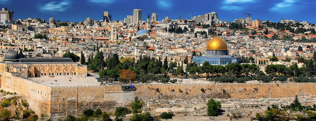
The Temple Mount
The Temple Mount is a 37-acre elevated platform in the southeastern corner of Jerusalem’s Old City. Herod the Great expanded it significantly in the late 1st century BCE, nearly doubling the natural hill’s surface area by building massive retaining walls and filling the interior. The Western Wall, the most visited Jewish prayer site in the world, is the western retaining wall of this expansion.
The platform Herod built is the same platform that exists today. The Dome of the Rock, constructed by Caliph Abd al-Malik between 688 and 692 CE, sits roughly over the location of the Temple’s Holy of Holies, though the precise alignment is disputed. Israeli archaeologist Leen Ritmeyer has argued, based on a rectangular notch cut into the bedrock beneath the Dome, that this marks the original position of the Ark of the Covenant. Others, including architect Tuvia Sagiv, place the Temple further south. Neither claim is provable given current access restrictions.
Archaeological excavation directly on the Temple Mount is politically impossible. What we know comes primarily from the massive excavations along the southern and southwestern walls led by Benjamin Mazar from 1968 to 1978. Mazar’s team uncovered the monumental staircase leading up to the Huldah Gates on the southern wall — the main public entrance to the Temple complex — along with market streets, ritual baths (miqva’ot), and the debris of the Roman destruction of 70 CE. The debris included enormous ashlar stones thrown from the top of the wall, exactly as Josephus described. One stone preserved an inscription reading “to the place of trumpeting,” identifying the spot where a priest would sound the shofar to mark the beginning and end of the Sabbath.
Most visitors photograph the Western Wall and look up at the Dome of the Rock. Few walk to the southwest corner, where the corner of Herod’s wall is still visible with the “Robinson’s Arch” — the spring of a massive arch that carried a staircase down to the street below, identified by Edward Robinson in 1838 and confirmed by Mazar’s excavations.
The City of David
Directly south of the Temple Mount, outside the current Old City walls, is the site of ancient Jerusalem. The city David captured from the Jebusites around 1000 BCE was not on the broad hilltop where most of the Old City now stands. It was on a narrow ridge above the Kidron Valley, close to the Gihon Spring, its only reliable water source.
Kathleen Kenyon’s excavations in the 1960s established the basic Bronze Age and Iron Age sequence at this site. Eilat Mazar’s excavations beginning in 2005 uncovered a large stone structure she identified as David’s palace, citing the “Large Stone Structure” and its pottery sequence dating to the 10th century BCE. Other archaeologists, including Israel Finkelstein and Amihai Mazar (no relation to Eilat), dispute the identification as a palace and question the 10th-century dating. The structure is real; what it was is genuinely uncertain.
More certain is Hezekiah’s Tunnel, cut through 533 meters of solid bedrock around 700 BCE to bring water from the Gihon Spring inside the city walls before the Assyrian siege of Jerusalem under Sennacherib. Visitors can walk through it today. The tunnel’s construction is described in 2 Kings 20:20 and 2 Chronicles 32:30, and confirmed by the Siloam Inscription, a 6-line Hebrew text carved near the tunnel’s exit describing the moment the two teams of workers, digging from opposite ends, broke through and heard each other’s voices. The inscription was discovered in 1880 and is now in Istanbul’s Archaeological Museum.
The tunnel exits at the Pool of Siloam. In 2004, Ronny Reich and Eli Shukron of the Israel Antiquities Authority excavated the pool’s southern end and found a large stepped pool with coins and pottery firmly dated to the Second Temple period. This is the pool where John 9 records Jesus healing a man born blind. The pool tourists were shown for decades, a small Byzantine-era basin further up the hill, is not it.
The Church of the Holy Sepulchre
The Church of the Holy Sepulchre, controlled jointly by six Christian denominations under a status quo arrangement dating to the Ottoman period, stands over the site that the emperor Constantine identified as Golgotha in 325-326 CE. He demolished a Roman temple of Aphrodite or Venus that Hadrian had built on the site after 135 CE, presumably over an earlier landmark, and constructed the first church.
The archaeological argument for the site’s authenticity rests primarily on topography. The church’s location was outside the city walls in the 1st century — a requirement for the execution of criminals under Jewish law. British archaeologist Joan Taylor examined the geological evidence in her 1998 book “Christians and the Holy Places” and confirmed that the rock formation beneath the church is consistent with a quarry and burial area at the city’s edge in the 1st century. Dan Bahat, former city archaeologist of Jerusalem, has made the same argument based on the distribution of Iron Age and Second Temple period tombs in the area.
The Garden Tomb, located north of the Damascus Gate, was identified by General Charles Gordon in 1883 partly on the basis of a nearby skull-shaped cliff (Gordon’s Calvary). Gabriel Barkay’s analysis of the tomb itself, published in the Biblical Archaeology Review in 1986, concluded that the rock-cut chamber’s form is consistent with Iron Age tombs, not 1st-century Jewish burial practice. This does not disqualify the site as meaningful for prayer and reflection, and many Protestant groups prefer its open-air setting. It simply is not, archaeologically speaking, a strong candidate for the 1st-century tomb described in the Gospels.
Most people don’t know this: inside the Church of the Holy Sepulchre, directly beneath a glass panel near the entrance, there is a quarry face with visible First Temple period tombs cut into it. Pilgrims walk past it without realizing it is the most direct physical evidence that this area was indeed outside the city and used for burial before the Roman period.
Galilee
Capernaum
On the northern shore of the Sea of Galilee, 3.5 kilometers from where the Jordan River enters the lake, stands the ruins of Capernaum. The site was excavated by Franciscan archaeologists from the 1960s onward, most extensively by Virgilio Corbo and Stanislao Loffreda, who published their findings in a multi-volume series from 1972 to 1985.
The visible remains divide into two layers. The 4th to 5th-century limestone synagogue is the best-preserved ancient synagogue in Israel and is what most visitors photograph. Beneath it, however, Corbo found the basalt stone foundations of an earlier synagogue, with pottery and coins dating it to the 1st century BCE through 1st century CE. This is the synagogue described in Luke 7, where a Roman centurion funds its construction. The visible limestone synagogue was built on top of it.
Sixty meters to the south, a separate excavation uncovered a series of domestic basalt-stone structures. One of them shows continuous habitation through the 1st century, then deliberate modification: the walls were plastered (unusual for Galilean domestic architecture), the room was enlarged, and then, in the 4th or 5th century, a distinctive octagonal church was built directly over it. Octagonal churches in Byzantine Christianity marked sites of particular veneration, typically a specific event or person. Egeria, a 4th-century pilgrim from Spain or Gaul, recorded in her travel diary that the house of Peter in Capernaum had been converted into a church. The graffiti scratched into the plaster of the earlier structure, invoking Jesus, Peter, and Christ, suggests this identification goes back considerably further. Whether the structure is definitively Peter’s house cannot be proven from the physical evidence alone. That it was consistently identified as such and venerated from an early period is well-documented.
Magdala
Seven kilometers south of Capernaum, Magdala sat on the western shore of the lake. Mary Magdalene took her name from this town. It appears in the Gospels as Magadan (Matthew 15:39) and Dalmanutha (Mark 8:10).
A 2009 excavation by Dina Avshalom-Gorni of the Israel Antiquities Authority, prompted by construction of a new pilgrim center, uncovered a 1st-century synagogue in near-perfect condition. The Magdala Stone, a carved limestone block found at the center of the synagogue, is decorated with a menorah relief that appears to be the oldest known carved depiction of the Second Temple menorah — predating the Temple’s destruction in 70 CE. It is also decorated with architectural motifs that match descriptions of the Temple’s facade in Josephus and in the Mishnah, suggesting the stone’s carver had direct visual knowledge of the Temple interior.
The synagogue is dated by pottery and coins to the 1st century CE. It was in active use during Jesus’s lifetime and, given its location and the Gospel accounts of his movements through the region, he almost certainly visited it. The site is now open to visitors and houses a small museum. Most tour itineraries still skip it in favor of the more famous synagogue at Capernaum.
Most people don’t know this: during the Magdala excavation, archaeologists found the remains of a market, a harbor, and a large pool consistent with the town’s reputation in Josephus as a fish-salting center. The “Magdala” that many Christians imagine as a small fishing village was in fact a prosperous commercial town of several thousand people.
Nazareth
Nazareth presents a challenge that the other Galilean sites do not. There is very little archaeological confirmation of a village at Nazareth during the Late Bronze Age or Iron Age, which led some scholars in the 1990s to question whether Nazareth existed in the 1st century. Ken Dark of the University of Reading led the Nazareth Archaeological Project from 2004 onward and found clear evidence of 1st-century habitation: rock-cut storage pits, agricultural terraces, wine presses, and domestic structures consistent with a small Galilean village. The “Nazareth house” Dark excavated and published in 2015 is a rock-cut structure with a courtyard and storage area, dated to the late 1st century BCE through 1st century CE, located beneath a convent near the center of modern Nazareth. It is not the house of the Holy Family and Dark does not claim it is. It is evidence that a 1st-century village existed here.
The Basilica of the Annunciation, completed in 1969 and the largest church in the Middle East, was built over a Crusader church, which was itself built over a Byzantine church. Beneath the current basilica, archaeologists have found remains of a 1st-century Jewish dwelling and, below that, a Hellenistic-period structure. These are visible through a grotto beneath the main floor. The tradition of venerating this specific location as Mary’s home goes back to the Byzantine period at minimum.
The White Mosque in the old city sits adjacent to what tradition identifies as the synagogue where Luke 4 records Jesus reading from Isaiah. No 1st-century synagogue structure has been excavated here, but the area of the old market and nearby Church of the Synagogue marks the traditional location.
Mount Tabor
Mount Tabor, a roughly conical hill rising 575 meters above the Jezreel Valley, is the most commonly accepted location for the Transfiguration, though the Gospels name only “a high mountain.” Origen, writing in the 3rd century, was the first to associate the event with Tabor. The competing identification is Mount Hermon, in the north near Caesarea Philippi, which better fits the geographical context of Matthew 16-17. The question remains open.
What is not in question is that Mount Tabor was heavily fortified in the Late Bronze and Iron Ages, served as the staging ground for Deborah and Barak’s battle against Sisera in Judges 4-5, and has been continuously venerated as a holy site since the Byzantine period. The present Franciscan basilica, completed in 1924 by architect Antonio Barluzzi, incorporates towers from the Crusader-period fortifications.
Sea of Galilee
The Sea of Galilee is a freshwater lake 21 kilometers long and 13 kilometers wide, fed by the Jordan River from the north and sitting 210 meters below sea level. The fishing industry in the 1st century was significant enough that Josephus describes a fleet of 230 boats on the lake during the Jewish revolt.
During a drought in 1986, when water levels dropped substantially, Moshe and Yuval Lufan noticed wooden planks exposed along the northwestern shore. The Israel Antiquities Authority excavated the boat over eleven days before rising water threatened it. Carbon-14 dating, confirmed by pottery found inside, placed the boat between 100 BCE and 70 CE. It is 8.2 meters long and 2.3 meters wide, clinker-built from cedar planks with oak frames, and capable of carrying 15 people. It is not, obviously, the specific boat of any Gospel account. It is the only physical example of the type of vessel described in those accounts. The boat is now preserved at Kibbutz Ginosar’s Yigal Allon Museum, 3 kilometers from Capernaum.
Bethlehem
Bethlehem sits 10 kilometers south of Jerusalem in the West Bank, administered by the Palestinian Authority. The Church of the Nativity, built by Constantine in 339 CE and substantially renovated by Justinian in the 6th century, is the oldest continuously operating Christian church in the world. The current floor retains portions of the original 4th-century mosaic from Constantine’s church, visible through trapdoors. A fire in 2015 revealed additional 4th-century floor mosaics beneath the plaster of a side chapel.
The grotto beneath the church, the specific spot marked by a 14-pointed silver star, has been venerated as Jesus’s birthplace since at least the 2nd century. Justin Martyr, writing around 155 CE, mentions the grotto in Bethlehem. Origen visited it in 215 CE and described a cave shown to locals and foreigners as the birthplace site. The cave tradition predates Constantine’s church by more than a century.
The competing tradition, reflected in Luke’s narrative detail of a manger and an inn with no room, has led some scholars to argue the birth occurred in an ordinary Bethlehem home where the ground-floor animal area served as sleeping quarters when the family room was full. Ken Bailey’s work on Palestinian peasant home architecture, particularly his 1979 paper “The Manger and the Inn,” argued that the word Luke uses for “inn” (kataluma) refers to a guest room in a private home, not a commercial inn. If Bailey is right, the nativity tradition fits a domestic cave-stable attached to a family home — which is also consistent with the cave venerated at the Church of the Nativity.
Most people don’t know this: the entrance to the Church of the Nativity is now a tiny door about 1.2 meters high, famously called the “Door of Humility.” It was not always that small. The original Constantinian entrance was wide and grand. It was narrowed first to prevent horses from entering and later, during the medieval period, reduced to its current size, probably to prevent casual desecration of the interior.
Jericho
Jericho is one of the oldest continuously inhabited places on Earth. Kathleen Kenyon’s excavations from 1952 to 1958, using stratigraphic methods that replaced the earlier, less rigorous work of John Garstang, established a settlement sequence going back approximately 11,000 years. The site of Tell es-Sultan, just outside modern Jericho, contains the remains of a Pre-Pottery Neolithic tower, roughly 9 meters tall and 9 meters in diameter, dated to around 8,000 BCE. It is the oldest freestanding stone tower known.
The walls of Jericho that Joshua “marched around” present a well-known problem: Kenyon found no evidence of Late Bronze Age occupation at Tell es-Sultan, which is the period (roughly 1,400-1,200 BCE) when most biblical chronologies place the Conquest. Garstang had previously identified a collapsed wall as the wall of Joshua, but Kenyon’s more careful stratigraphy showed it dated to the Early Bronze Age, roughly 2,400 BCE — at least 1,000 years too early. Bryant Wood, writing in the Biblical Archaeology Review in 1990, challenged Kenyon’s conclusion and argued that ceramic evidence she dismissed actually supports a Late Bronze Age destruction. The exchange between Wood and Kenyon’s colleague Piotr Bienkowski in subsequent issues of BAR represents the state of the argument clearly. Neither side has definitively closed the case.
New Testament Jericho is a different site. Herod the Great built a winter palace 2 kilometers south of Tell es-Sultan, in the Wadi Qelt, with swimming pools, sunken gardens, and a hippodrome. Ehud Netzer of Hebrew University excavated this site from the 1970s onward. It is the Jericho of Zacchaeus the tax collector (Luke 19) and of the road to Jericho in the parable of the Good Samaritan.
Masada
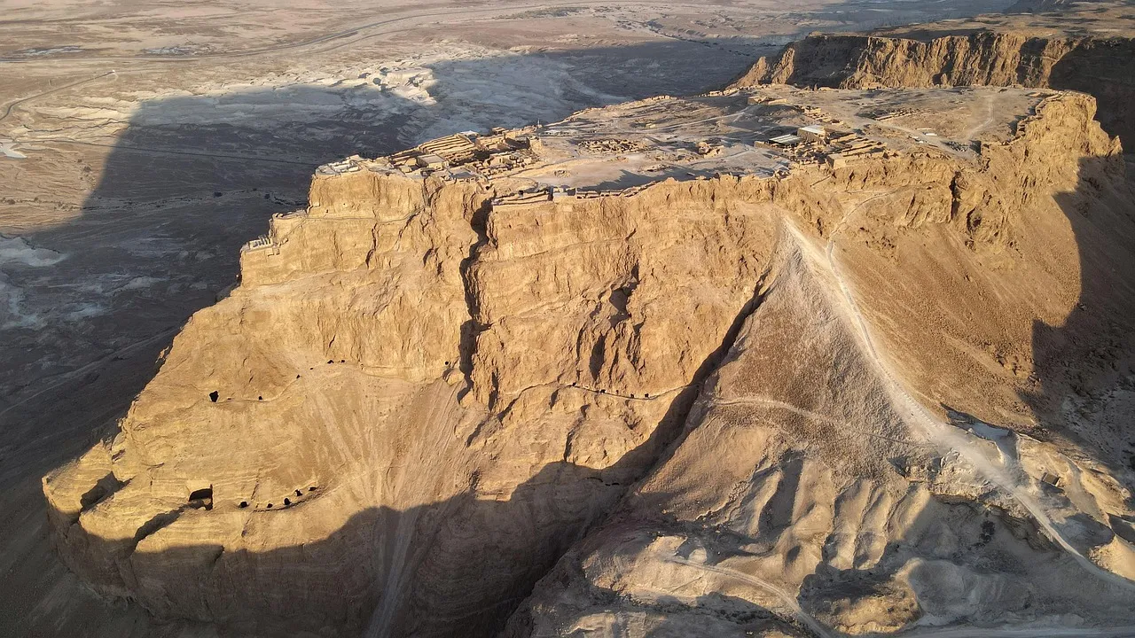
Masada is a natural mesa rising 450 meters above the Dead Sea’s western shore, with sheer cliffs on every side. Herod the Great built two palaces there, along with storerooms, bathhouses, and a sophisticated water collection system of cisterns cut into the rock and fed by aqueducts. The cisterns’ total capacity was approximately 40,000 cubic meters.
Yigael Yadin’s excavations from 1963 to 1965, one of the largest archaeological operations in Israeli history and involving roughly 5,000 volunteers, uncovered Herod’s northern palace, the 1st-century synagogue (one of the oldest in the world), and the remains of the Jewish defenders who held Masada against Rome until 73 CE. Yadin found skeletal remains, personal belongings, and 11 ostraca (pottery shards with names written on them) in one location. He interpreted these as the lots the defenders drew to determine who would kill the others before the final man took his own life, as described by Josephus in the Jewish War. Some later archaeologists have questioned whether the 11 ostraca can bear that interpretation, but the physical evidence of a determined last stand is unmistakable. The Roman siege ramp, built by the 10th Legion, is still visible on the western side of the mesa.
The site was designated a UNESCO World Heritage Site in 2001.
Qumran and the Dead Sea Scrolls
In the winter of 1946-47, a Bedouin shepherd named Muhammad edh-Dhib was searching for a stray goat in the caves above the northwestern shore of the Dead Sea when he found ceramic jars containing ancient manuscripts wrapped in linen. This is not legend; it is the account edh-Dhib gave consistently to archaeologists including John Allegro, and it is the established origin of what became the most significant manuscript discovery of the 20th century.
Roland de Vaux of the Ecole Biblique in Jerusalem led systematic excavations of the site of Khirbet Qumran and the surrounding caves between 1951 and 1956. Eleven caves containing manuscript material were identified. In total, roughly 900 manuscripts were recovered in varying states of preservation, representing every book of the Hebrew Bible except Esther, along with previously unknown sectarian texts including the Community Rule, the War Scroll, and the Temple Scroll.
The Great Isaiah Scroll (1QIsa-a), now housed in the Shrine of the Book at the Israel Museum, is dated by radiocarbon testing to approximately 125-100 BCE. It predates the previously oldest known Hebrew manuscript of Isaiah (the Aleppo Codex, 10th century CE) by roughly 1,000 years. The Isaiah Scroll’s text is nearly identical to the Masoretic text used in modern Bible translations, with only minor variations — a fact that strengthens confidence in the reliability of the transmission process.
The community at Qumran is generally identified with the Essenes, a Jewish sect described by Josephus, Philo, and Pliny the Elder. Pliny specifically locates the Essenes on the western shore of the Dead Sea, above Engedi — a description that fits Qumran. However, Norman Golb of the University of Chicago argued in his 1995 book “Who Wrote the Dead Sea Scrolls?” that the scrolls are not the product of a single sectarian community but represent a library evacuated from Jerusalem before the Roman siege of 70 CE. The sectarian hypothesis remains the majority position, but Golb’s challenge was not frivolous and the debate has sharpened the field’s thinking about provenance.
The visitor center at Qumran is functional without being exceptional. The caves themselves are a short walk from the site. Most people don’t know that Cave 4, which contained the largest number of fragments, is visible directly across a small ravine from the main ruins — you can see it from the site without any hiking. For a thorough treatment of the manuscripts themselves — their contents, dating, and what they demonstrate about the textual transmission of the Hebrew Bible — see the full guide to the Dead Sea Scrolls.
Caesarea Maritima
Herod the Great built the harbor city of Caesarea on the Mediterranean coast between 22 and 10 BCE, constructing what was then one of the largest artificial harbors in the Roman world. He named it in honor of Augustus Caesar. The harbor, called Sebastos (Greek for Augustus), was built using hydraulic concrete, an early application of this Roman technology, and included a massive breakwater, warehouses, a lighthouse, and a temple to Rome and Augustus visible from the sea.
Robert Hohlfelder and Robert Lindley Vann led underwater excavations of the harbor in the 1980s as part of the Caesarea Ancient Harbour Excavation Project, confirming Josephus’s description in detail. The harbor’s remains are now partially visible from glass-bottom boats and the underwater section of the national park.
On land, the combined excavations of the Hebrew University and the joint Caesarea Expedition (led by Avner Raban and Kenneth Holum among others, with major publications in the 1990s through 2000s) have exposed the Roman theater, the Herodian palace built on a promontory into the sea, the hippodrome, a Byzantine street, and Crusader fortifications. The promontory palace is where Pontius Pilate would have resided when he was not in Jerusalem. In 1961, Italian excavators found the Pilate Stone — a limestone block bearing the Latin inscription “[Tibe]rieum … [Pon]tius Pilatus … [Praef]ectus Iuda[eae]” — the first and still only contemporary inscription confirming Pontius Pilate’s existence and title. The original is in the Israel Museum; a cast is at the Caesarea site.
The book of Acts locates significant events at Caesarea: Peter’s conversion of the Roman centurion Cornelius (Acts 10), Philip the Evangelist’s home (Acts 21:8), and Paul’s two-year imprisonment before his voyage to Rome (Acts 23-27). The prison where Paul was held was likely in or near the Herodian praetorium, the palace complex on the promontory.
Megiddo
Megiddo sits at the entrance to the Jezreel Valley’s western pass, the main route connecting Egypt and Mesopotamia, and has been fought over as long as human beings have lived in the Levant. The Egyptian pharaoh Thutmose III fought the first recorded battle in history here in 1457 BCE, according to inscriptions at the Karnak temple. The site appears in Revelation 16:16 as Har Megiddo — Armageddon.
The Oriental Institute of the University of Chicago excavated Megiddo from 1925 to 1939, and subsequent excavations by the Hebrew University have continued into the present century. Tell Megiddo is a mound of roughly 26 occupation layers, spanning from the Neolithic period through the Persian period. The Late Bronze Age Canaanite temple complex, the Solomonic-period gates (cited in 1 Kings 9:15, though Israel Finkelstein and David Ussishkin have debated whether these gates are Solomonic or Omride in date), and the elaborate water system with its 30-meter vertical shaft are all visible.
The stables found at Megiddo — long, narrow structures with stone pillars and troughs, excavated by the Oriental Institute — were initially attributed to Solomon based on 1 Kings 10:26, which mentions his chariot cities. Yadin revised this to an Ahab-period (9th century BCE) attribution, and the debate over the dating and function of these structures continues. Some archaeologists have argued the structures are not stables at all but storehouses. The visitor center presents the stables identification confidently, which is a few steps ahead of the published literature.
Most people don’t know this: a Canaanite bronze-age temple at Megiddo, excavated in the 1930s, contained the largest known collection of carved ivory objects from the ancient Near East — 382 pieces including gaming boards, combs, and figurines, found in a single room. They are now in the Israel Museum and the Rockefeller Museum in Jerusalem and date to the 12th century BCE.
Planning your visit
Before planning a route, it is worth understanding which sites are well-supported by excavation and which rest primarily on medieval tradition. The article on where Jesus actually walked: archaeology vs. tradition ranks the 10 most-visited Jesus sites by the quality of their evidence — useful background before committing to an itinerary.
A serious pilgrimage to these sites needs at minimum 10 days. Two days in Jerusalem allow time for the Old City, the City of David, and the Mount of Olives without the breathless pace that compresses everything. Two days based in Tiberias cover the Galilee sites. Day trips from Jerusalem handle Bethlehem, Jericho, Masada, Qumran, and Caesarea, though Caesarea is more naturally visited en route between Jerusalem and Galilee. For groups organizing a church-led trip, the full logistics of planning your church pilgrimage — from rooming lists to site access permits — are covered in a separate guide.
Every group is different. A group focused on the Gospels will prioritize Galilee. A group working through Acts will want more time in Jerusalem and at Caesarea. A group with a strong Old Testament interest should not skip Megiddo, the City of David, or Lachish (if time allows). There is no itinerary that fits everyone.
What does not vary is the density of the material and the pace at which most people absorb it. Budget is also a factor groups underestimate; a realistic breakdown of what a 10-day Israel pilgrimage costs helps avoid the sticker shock that tends to come after commitments have already been made. For first-time visitors, a practical guide to Israeli food and culture is worth reading before departure. The visitors who come away having genuinely learned something are the ones who did some preparation before they arrived. This guide is a starting point.
