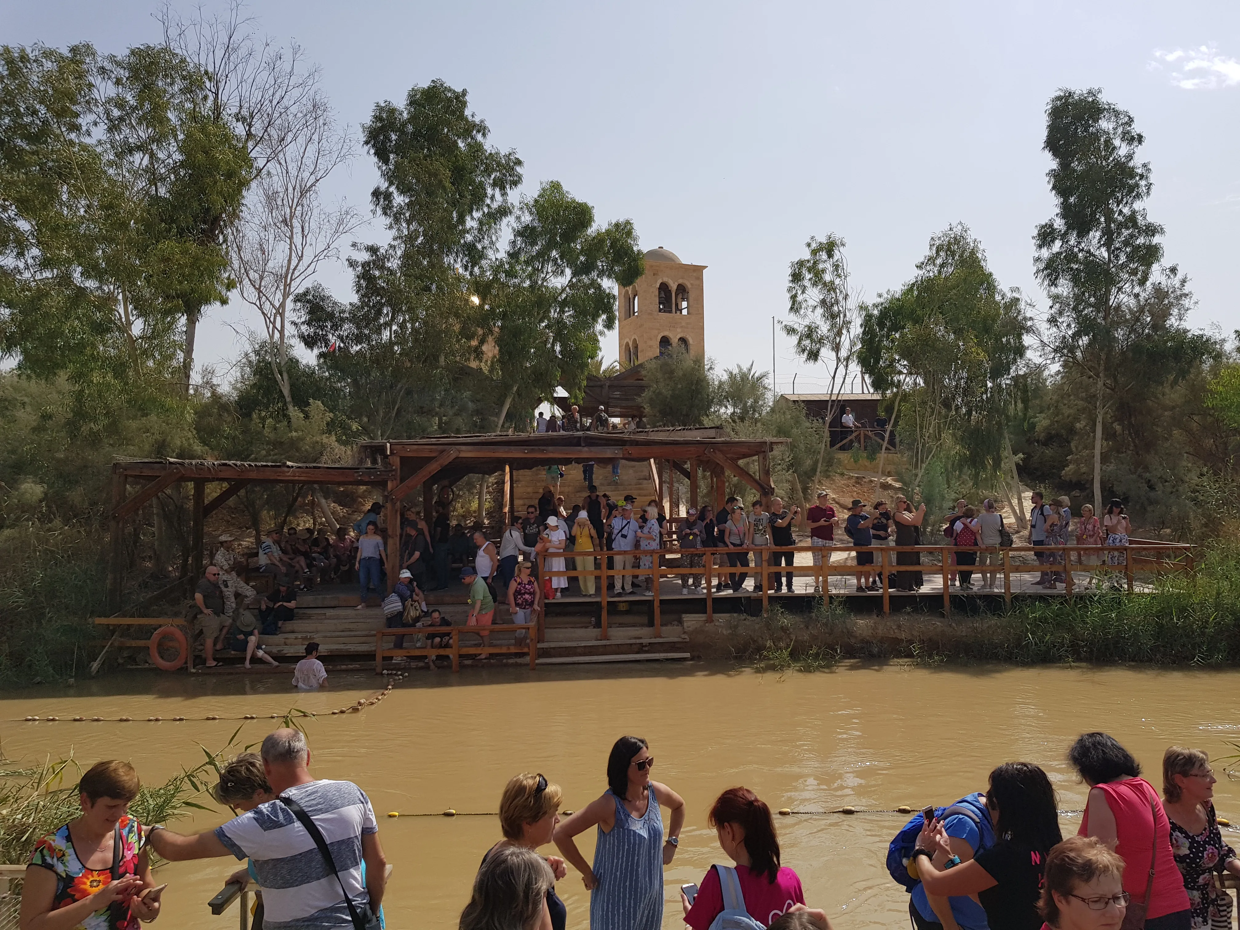
The Qasr el-Yahud baptism site sits on the western bank of the Jordan River, ten kilometers east of Jericho, at the point Christian tradition has identified since at least the 4th century as the place where John the Baptist baptized Jesus. The name in Arabic means “castle of the Jews,” a reference to the medieval monastery complex on the site rather than to any earlier identification. For most of the 20th century the location was inaccessible to pilgrims. It reopened to public access only in 2011, and large portions of the surrounding monastic compounds emerged from demining as recently as 2020.
This guide covers the scriptural and archaeological case for the identification, the Byzantine pilgrim record that fixed the tradition, the modern history that closed the site, and the practical details that determine whether a group baptism here goes smoothly. For broader context on the river itself, see the Jordan River baptism guide and the companion piece on the Jordan River in biblical history. Groups looking to build Qasr el-Yahud into a full 10-day Israel itinerary can see how it fits on the Walk Where Jesus Walked tour page.
The Gospel geography
All four canonical Gospels place the baptism of Jesus in the Jordan River. Matthew 3:13-17, Mark 1:9-11, and Luke 3:21-22 describe the event itself. John 1:28 supplies the location: “These things were done in Bethany beyond the Jordan, where John was baptizing.” The phrase “beyond the Jordan” (peran tou Iordanou in Greek) means on the eastern side from a Judean perspective, that is, the Transjordanian bank.
The Bethany of John 1:28 is not the village near Jerusalem where Lazarus lived. It is a separate site, sometimes called Bethany-beyond-the-Jordan or Bethabara in later manuscripts, located in what is today the Kingdom of Jordan. The site directly across the river from Qasr el-Yahud, known in Arabic as Al-Maghtas, was inscribed by UNESCO in 2015 as the location of the baptism. The two banks face each other at the same crossing.
The geography matters because crossings of the Jordan are limited. The river is shallow and fordable at relatively few points, and this particular ford had served as a crossing since at least the time of Joshua. Joshua 3:16 describes the Israelites crossing the Jordan on dry ground “near Adam, the city beside Zarethan,” with the water cut off “as far as the city of Adam.” The traditional site of that crossing, identified by 4th-century pilgrims and reaffirmed in the Madaba Map, is the same crossing where John the Baptist later worked. The connection between Joshua’s crossing and Jesus’s baptism, both at the same ford, is theologically suggestive and was emphasized in early Christian commentary.
The Byzantine pilgrim record
The earliest detailed pilgrim account of the baptism site comes from Egeria, a nun (likely Spanish or Gaulish) who traveled the Holy Land between 381 and 384 CE and wrote a detailed account of her itinerary. Egeria describes liturgical celebrations at the Jordan baptism site on the feast of Epiphany, including night vigils and water blessings, that presuppose an established sanctuary already in regular use by the late 4th century.
The Madaba Map, a 6th-century mosaic floor map of the Holy Land preserved in the Church of Saint George at Madaba in modern Jordan, shows the baptism site explicitly. The relevant section depicts the Jordan flowing into the Dead Sea, with a labeled site on the western bank reading “Bethabara, the place of baptism of Saint John.” The map dates to roughly 560 CE and represents the consensus identification in use across the Byzantine church at that time.
Several Byzantine monasteries clustered around the site between the 4th and 7th centuries: the Monastery of Saint John the Baptist (Greek Orthodox, with foundations dating to the 5th century), the Monastery of Saint Gerasimus a few kilometers south, and several smaller foundations attested in pilgrim itineraries but not yet excavated in detail. The Persian invasion of 614 CE damaged most of these foundations. The Crusader period saw partial reconstruction, and the Ottoman era saw further monastic activity. The structures visible on the western bank today, including the Greek Orthodox, Romanian, Ethiopian, Coptic, Russian, and Syrian compounds, are largely 19th and early 20th century rebuildings on Byzantine foundations.
Archaeological evidence
Excavations on the eastern (Jordanian) bank, conducted by the Jordanian archaeologist Mohammad Waheeb beginning in 1996, identified more than 20 churches, baptismal pools, hermit caves, and pilgrim-related structures dating from the 1st through 6th centuries CE. The most significant finding is a series of stepped baptismal pools fed by springs from the Wadi Kharrar, with associated 5th and 6th century church foundations. These pools sit slightly inland from the current riverbank and reflect the Byzantine liturgical preference for controlled-water baptism over direct immersion in the Jordan itself.
On the western bank at Qasr el-Yahud, archaeological work has been more limited because of the minefields, but surveys have documented Byzantine and early Islamic pottery, mosaic fragments, and structural remains consistent with continuous monastic occupation from the 5th century onward. The Israel Antiquities Authority conducted salvage work during the 2011 access development and during HALO Trust demining operations in 2018-2020.
The combined eastern and western evidence places early Christian baptismal activity at this exact crossing of the Jordan from at least the 4th century. That does not prove the historical Jesus was baptized at this specific point. It does establish that the identification is early, geographically coherent with the Gospel text, and supported by physical remains. For the broader pattern of how archaeology evaluates Gospel-era sites, see the survey of what archaeology has actually found at the sites associated with Jesus.
Why the site was closed for fifty years
After the Six-Day War in 1967, the Jordan River became the de facto military boundary between Israel and Jordan. The Israeli military mined the western bank and the surrounding monastic compounds extensively, and the area was placed under closed military zone status. The monasteries were evacuated. Monks left behind liturgical objects, books, and personal effects that remained in place for decades.
The site reopened to limited pilgrim access in 2011, with a paved access road, basic facilities, and a fenced corridor leading from the parking area to the riverbank. The surrounding monastic compounds, however, remained behind minefields. Beginning in 2018, the British demining charity HALO Trust began clearing the monastery grounds, working systematically through the Greek Orthodox, Ethiopian, Franciscan, Coptic, Romanian, Russian, and Syrian compounds. By 2020 the major churches had been declared mine-free, and several monastic communities have since returned to partial occupation.
Some areas adjacent to the public site remain fenced and uncleared. Visitors should treat all fenced or signed-off areas as live and stay strictly within marked paths.
Practical visitor information
Qasr el-Yahud is in the West Bank, in Area C under the Oslo Accords, and is administered by the Israel Nature and Parks Authority. Access is via Route 90 north of the Dead Sea, with a signed turnoff approximately 10 kilometers east of Jericho. There is no admission fee. The site is open daily from 8:00 AM to 4:00 PM in winter and 8:00 AM to 5:00 PM in summer, with last entry typically 30 minutes before closing.
Group buses can drive directly to the site parking area. There are no IDF checkpoints on the access road during normal operations, though the route runs through territory under Israeli military administration and conditions can change. Tour operators typically check current access status on the day of travel.
The baptism platform has changing rooms (separate for men and women), handrails into the water, and benches for groups. White baptismal robes are sold on site (cash recommended) or can be supplied by tour operators. Modesty is expected, both for the baptism itself and in the surrounding plaza area, where Eastern Orthodox monks and pilgrim groups are often present. Shoulders and knees covered is the working standard.
The water carries significant agricultural and treated-wastewater load from the upper Jordan and from Israeli, Palestinian, and Jordanian sources. EcoPeace Middle East has documented the contamination in detail. The Israeli Ministry of Health has at various points advised against full head immersion. Most pilgrims proceed regardless, with practical precautions: do not swallow the water, do not enter with open wounds, shower soon after.
For groups planning a baptism here, allow 90 minutes minimum on site. A typical schedule includes 15 minutes for orientation, 20 minutes for changing, 30 to 45 minutes for the baptism itself with prayers and Scripture readings, and time to redress and return to the bus. Tour operators handling church groups regularly coordinate timing through the site office to avoid overlap with other large groups, particularly during the Epiphany season in early January and during Easter week. The companion guide on planning a group baptism on the Jordan River covers logistics in more detail.
For pilgrims comparing baptism locations, the Yardenit baptism site guide covers the alternative on the Israeli side near the Sea of Galilee. Yardenit offers easier access, no security considerations, and a developed visitor complex, but no scriptural or archaeological connection to the baptism of Jesus. Many groups visit both, treating Qasr el-Yahud as the historically grounded site and Yardenit as a practical fallback when access conditions or schedule constraints make the West Bank site difficult.
A full day in the lower Jordan Valley typically combines Qasr el-Yahud with Jericho, Qumran, and either Masada or the Dead Sea. Groups continuing north afterward usually overnight in Tiberias and begin the Galilee portion of the itinerary the next morning, starting with the Sea of Galilee complete guide sites.